
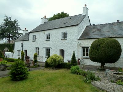
Swimbridge Farmhouse with attached garden walls, Grade II listed building in Vale of Glamorgan. About 200m north of the Church of St. Illtud
Locatie: Llantwit Major
Hoogte boven de zeespiegel: 42,5 m
GPS-coördinaten: 51.40970,-3.48823
Laatste update: 12 maart 2025 om 00:45

St Illtyd's Church, Llantwit Major
193 m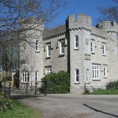
Dimlands
980 m
Llantwit Major Town Hall
242 m
Well opposite Downcross Farm
236 m
Bethel Baptist Chapel
221 m
Tudor Tavern P.H.
220 m
The Old Police Station
257 m
Old White Hart P.H.
183 m
Old Swan Inn
221 m
Llantwit Major War Memorial
195 m
Telephone Call-Box outside Old White Hart P.H.
186 m
Old Place (or Llantwit Major Castle)
123 m
Court House
214 m
Tabernacle Calvinistic Methodist Chapel
353 m
Downcross Farmhouse including front garden walls
256 m
Plymouth House
98 m
West Farmhouse
50 m
Cross in Churchyard of Church of St. Illtud
206 m
Outhouse at Sunny Bank
231 m
Ty-mawr
337 m
The Gatehouse (porter's Room)
246 m
Corner House
170 m
Footbridge over brook at West entrance to churchyard of Church of St Illtud
202 m
The Old School, including attached walling
123 m
Llantwit Major Dovecote
302 m
Former Chantry Priest's House
221 m
Quaintways, with attached garden wall
422 m
Chantry House
247 mBeoordelingen
Heeft u deze plek bezocht? Tik op de sterren om een beoordeling te geven en uw ervaring of foto's te delen met de community! Probeer het nu! U kunt het op elk moment annuleren.
Ontdek verborgen schatten op elk avontuur!
Van karakteristieke kleine cafeetjes tot geheime uitzichtpunten – ontvlucht de drukte en vind plekken die echt bij jou passen. Onze app maakt het makkelijk: spraakzoekopdrachten, slimme filters, geoptimaliseerde routes en authentieke tips van reizigers wereldwijd. Download nu en beleef het avontuur op je smartphone!

Een nieuwe benadering van toeristische ontdekking❞
— Le Figaro
Alle plekken die de moeite waard zijn om te ontdekken❞
— France Info
Een uitstapje op maat in slechts een paar klikken❞
— 20 Minutes