
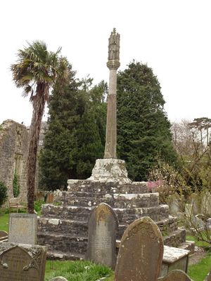
Cross in Churchyard of Church of St. Illtud, Grade II listed building in Vale of Glamorgan. On the south side of the Church of St. Illtud and about 20m from the south porch
Locatie: Llantwit Major
Hoogte boven de zeespiegel: 36,3 m
GPS-coördinaten: 51.40788,-3.48767
Laatste update: 9 maart 2025 om 04:20

St Illtyd's Church, Llantwit Major
14 m
Llantwit Major Town Hall
113 m
Well opposite Downcross Farm
432 m
Bethel Baptist Chapel
229 m
Tudor Tavern P.H.
95 m
The Old Police Station
75 m
Old Swan Inn
126 m
Old White Hart P.H.
83 m
Llantwit Major War Memorial
92 m
Telephone Call-Box outside Old White Hart P.H.
95 m
Court House
270 m
Downcross Farmhouse including front garden walls
447 m
Tabernacle Calvinistic Methodist Chapel
160 m
West Farmhouse
218 m
Plymouth House
158 m
Old Place (or Llantwit Major Castle)
325 m
Ty-mawr
528 m
Outhouse at Sunny Bank
402 m
Former Chantry Priest's House
17 m
Swimbridge Farmhouse with attached garden walls
206 m
Corner House
329 m
Footbridge over brook at West entrance to churchyard of Church of St Illtud
44 m
Chantry House
45 m
The Old School, including attached walling
97 m
The Old House
351 m
The Gatehouse (porter's Room)
73 m
Quaintways, with attached garden wall
243 m
Llantwit Major Dovecote
122 mHeeft u deze plek bezocht? Tik op de sterren om een beoordeling te geven en uw ervaring of foto's te delen met de community! Probeer het nu! U kunt het op elk moment annuleren.
Ontdek verborgen schatten op elk avontuur!
Van karakteristieke kleine cafeetjes tot geheime uitzichtpunten – ontvlucht de drukte en vind plekken die echt bij jou passen. Onze app maakt het makkelijk: spraakzoekopdrachten, slimme filters, geoptimaliseerde routes en authentieke tips van reizigers wereldwijd. Download nu en beleef het avontuur op je smartphone!

Een nieuwe benadering van toeristische ontdekking❞
— Le Figaro
Alle plekken die de moeite waard zijn om te ontdekken❞
— France Info
Een uitstapje op maat in slechts een paar klikken❞
— 20 Minutes