
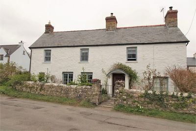
Downcross Farmhouse including front garden walls, About 100m south of Great House
Locatie: Llantwit Major
Hoogte boven de zeespiegel: 47,5 m
GPS-coördinaten: 51.41187,-3.48704
Laatste update: 16 maart 2025 om 19:50

St Illtyd's Church, Llantwit Major
433 m
Dimlands
1.2 km
Llantwit Major Town Hall
436 m
Well opposite Downcross Farm
30 m
Bethel Baptist Chapel
324 m
Tudor Tavern P.H.
422 m
The Old Police Station
508 m
Old White Hart P.H.
394 m
Old Swan Inn
404 m
Llantwit Major War Memorial
399 m
Telephone Call-Box outside Old White Hart P.H.
389 m
Cross in Churchyard of Church of St. Illtud
447 m
Court House
272 m
Tabernacle Calvinistic Methodist Chapel
567 m
West Farmhouse
279 m
Plymouth House
350 m
Old Place (or Llantwit Major Castle)
138 m
Outhouse at Sunny Bank
75 m
Ty-mawr
82 m
Swimbridge Farmhouse with attached garden walls
256 m
The Gatehouse (porter's Room)
498 m
Corner House
134 m
Footbridge over brook at West entrance to churchyard of Church of St Illtud
453 m
The Old School, including attached walling
351 m
Llantwit Major Dovecote
555 m
Former Chantry Priest's House
463 m
Quaintways, with attached garden wall
615 m
Chantry House
491 mBeoordelingen
Heeft u deze plek bezocht? Tik op de sterren om een beoordeling te geven en uw ervaring of foto's te delen met de community! Probeer het nu! U kunt het op elk moment annuleren.
Ontdek verborgen schatten op elk avontuur!
Van karakteristieke kleine cafeetjes tot geheime uitzichtpunten – ontvlucht de drukte en vind plekken die echt bij jou passen. Onze app maakt het makkelijk: spraakzoekopdrachten, slimme filters, geoptimaliseerde routes en authentieke tips van reizigers wereldwijd. Download nu en beleef het avontuur op je smartphone!

Een nieuwe benadering van toeristische ontdekking❞
— Le Figaro
Alle plekken die de moeite waard zijn om te ontdekken❞
— France Info
Een uitstapje op maat in slechts een paar klikken❞
— 20 Minutes