
Stable Block Approximately 100 Metres West Of Ashtead Park House
Stable Block Approximately 100 Metres West Of Ashtead Park House, stable in Mole Valley, Surrey, UK
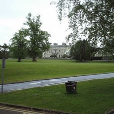
Ashtead Park
141 m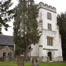
Church of St Giles, Ashtead
117 m
Bridgman Monument Approximately 8 Metres South Of Corner Of Chancel Of Church Of St Giles
95 m
Hamelot Monument Approximately 18 Metres South East Of Chancel Of Church Of St Giles
80 m
Bridge At Rookery Hill
313 m
Howard Cottage Ivy Cottage
729 m
The Howard Memorial Fountain
635 m
Two Tomb Chests Approximately 27 Metres South Of Church Of St Giles
80 m
Ashtead House
506 m
Coal Tax Post At Tq 200 579
679 m
The Old Rectory
678 m
Row Of 7 Headstones And 4 Footstones From Approximately 17 To Approximately 25 Metres South Of Church Of St Giles
85 m
Wheldon Headstone Approximately 8 Metres East Of Chancel Of Church Of St Giles
105 m
Walls And Balustrades To Terraced Garden On North Side Of Ashtead Park House
146 m
Sundial In Centre Of Forecourt In Front Of South Front Of Ashtead Park House
162 m
Gate Piers And Gates To Ashtead Park At Juncton Of Farm Lane And Pleasure Pit
424 m
Ashtead Park House And Attached Balustrades
152 m
Group Of 4 Headstones And 1 Footstone Approximately 2 Metres South West Of Porch Of Church Of St Giles
111 m
Earthworks near St Giles' Church
233 m
Coal Tax Post Near Junction With Headley Road
645 m
Monument 5 Metres South Of Chancel Of Church Of St Giles
105 m
Group Of 7 Headstones And 5 Footstones From Approximately 17 To Approximately 25 Metres South Of Church Of St Giles
90 m
The Old Bakery
673 m
Ice House In Grounds Of Marsden Nurseries, Approximately 140 Metres North East Of Ashtead House
655 m
Walls Enclosing Walled Garden Beside Lane Opposite Ashtead House And North Of Headmasters House
526 m
Gatepiers With Associated Gates And Railings At Entrances To Rookery Hill And Drive To Church Of St Giles
368 m
Beckford Monument Approximately 8 Metres East Of Chancel Of Church Of St Giles
99 m
Headmaster's House
400 mBeoordelingen
Heeft u deze plek bezocht? Tik op de sterren om een beoordeling te geven en uw ervaring of foto's te delen met de community! Probeer het nu! U kunt het op elk moment annuleren.
Ontdek verborgen schatten op elk avontuur!
Van karakteristieke kleine cafeetjes tot geheime uitzichtpunten – ontvlucht de drukte en vind plekken die echt bij jou passen. Onze app maakt het makkelijk: spraakzoekopdrachten, slimme filters, geoptimaliseerde routes en authentieke tips van reizigers wereldwijd. Download nu en beleef het avontuur op je smartphone!

Een nieuwe benadering van toeristische ontdekking❞
— Le Figaro
Alle plekken die de moeite waard zijn om te ontdekken❞
— France Info
Een uitstapje op maat in slechts een paar klikken❞
— 20 Minutes