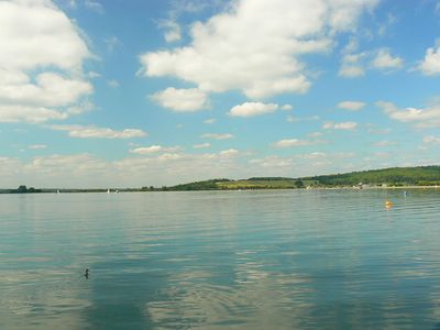
Farmoor Reservoir, meer in het Verenigd Koninkrijk
Farmoor Reservoir is een groot waterbekken in de Vale of White Horse, beheerd door Thames Water en verdeeld in twee bassins verbonden door een dijk. De plaats omvat een zeilclub, vogelkijkhokken en aangrenzende natuurreservaten zoals Pinkhill Reserve met ondiepe vijvers en Shrike Meadow, plus toegankelijke wandelpaden rond de omtrek.
Het stuwmeer werd gebouwd om water voor de regio op te slaan en is al tientallen jaren een bekend vogelkijkgebied. Shrike Meadow werd in 2000 geopend en genoemd naar een Klauwier die daar ooit werd gezien, wat de groeiende erkenning van de plaats als natuurobservatieverband weerspiegelt.
De plek trekt lokale vogelspotters en natuurliefhebbers aan die regelmatig samenkomen om dieren en planten waar te nemen en vast te leggen. Deze activiteiten hebben een informele gemeenschap van bezoekers gecreëerd die hun waarnemingen delen en bijdragen aan een lange traditie van voorzichtig natuuronderzoek.
Plan uw bezoek op basis van het seizoen: winter brengt eenden en meeuwen, zomer biedt broedende sterns en andere watervogels, en migratieperiodes kunnen ongebruikelijke soorten onthullen. De plaats is gemakkelijk bereikbaar met de auto met voldoende parkeerplaatsen, toegankelijke toiletten en vlakke wandelpaden die geen speciale vergunningen vereisen, tenzij u vogelkijkhokken wilt betreden.
De plaats staat bekend om ongebruikelijke meeuwsoorten zoals IJsmeewen aan te trekken tijdens of na stormen, wat vogelspotters aantrekt die op zoek zijn naar zeldzame waarnemingen. Deze onverwachte bezoekers verschijnen wanneer weerverstoringen vogels ver uit hun gebruikelijke habitats duwen, waardoor het meer een opwindende bestemming is voor wie hoopt iets buitengewoons te zien.
De community van nieuwsgierige reizigers
AroundUs brengt duizenden geselecteerde plaatsen, lokale tips en verborgen pareltjes samen, dagelijks verrijkt door meer dan 60,000 bijdragers wereldwijd.