Locatie inschakelen

We hebben je locatie nodig om interessante plaatsen in je buurt te tonen

Ontdek plaatsen in de buurt

Vind interessante locaties en verborgen pareltjes om je heen

Precieze routebeschrijving

Krijg nauwkeurige routebeschrijvingen en afstanden naar plaatsen

Je locatie wordt nooit gedeeld met andere gebruikers. Het wordt alleen gebruikt wanneer je op de locatieknop tikt.

Burton Manor

Inloggen op je account

Doe mee aan het avontuur

Maak je gratis account aan en begin met ontdekken (zoals 60k+ anderen)

We sturen je een code om te verbinden

of
Doorgaan met Google
Doorgaan met Apple
Door door te gaan, accepteer je onze Algemene voorwaarden en ons Privacybeleid

Controleer je inbox

We hebben een pincode naar uw inbox gestuurd. Voer de code hieronder in.

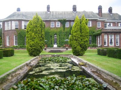
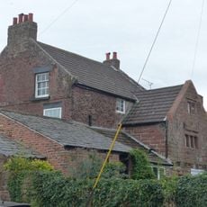
Burton Manor, Landhuis in Burton, Engeland.

Beschrijving

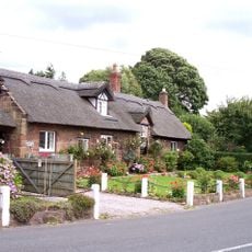
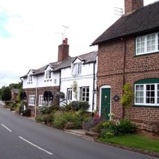
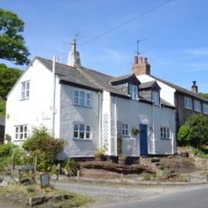
Burton Manor is een huis gebouwd van rood zandsteen met groene leisteen daken en sierlijke schoorstenen van steen en baksteen. Het gebouw staat in ommuutde tuinen en landschappelijke terreinen die een geregistreerd historisch park vormen.

Geschiedenis

Het huis werd in 1805 gebouwd voor Richard Congreve en ondergingen in 1904 grote veranderingen door architect Charles Nicholson. Deze wijzigingen werden aangebracht voor Henry Neville Gladstone, wiens vader Eerste Minister was.

Cultuur

Het landgoed diende gedurende jaren als volwassenenonderwijs centrum, waar studenten kwamen om te leren en te verblijven. Deze onderwijskundige rol vormde hoe lokale mensen dit plaats waardeerden en gebruikten.

Praktisch

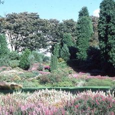
De ommuutde tuin is toegankelijk voor bezoekers en wordt onderhouden door een plaatselijke organisatie die zich aan behoud wijdt. U kunt de terreinen in uw eigen tempo verkennen en moet zich voorbereiden op wandelingen door verschillende delen van het landgoed.

Wist je dat?

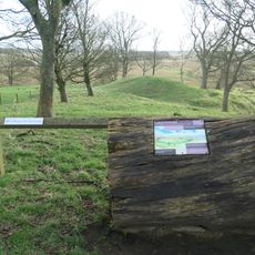
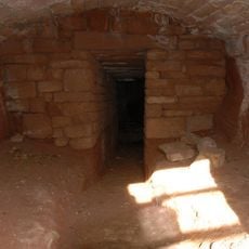
Het terrein bevat een historisch ijshuis dat beschermd is als een geregistreerd monument. Deze ondergrondse structuur laat zien hoe mensen voedsel bewaarden voor de uitvinding van moderne koeling.

GPS-coördinaten
53.25960,-3.02850
Laatste update
8 december 2025 om 22:00

AroundUs brengt duizenden geselecteerde plaatsen, lokale tips en verborgen pareltjes samen, dagelijks verrijkt door meer dan 60,000 bijdragers wereldwijd. Ontdek alle plaatsen in de buurt (Cheshire West and Chester).

Rond deze plek
Ness Botanic Gardens
Verenigd Koninkrijk

Ness Botanic Gardens

1.7 km
St Michael's Church, Shotwick
Verenigd Koninkrijk

St Michael's Church, Shotwick

3.2 km
Shotwick Hall
Verenigd Koninkrijk

Shotwick Hall

3.1 km
Burton Point
Verenigd Koninkrijk

Burton Point

1.3 km
St Nicholas' Church, Burton
Verenigd Koninkrijk

St Nicholas' Church, Burton

330 m
Bishop Wilson's House
Verenigd Koninkrijk

Bishop Wilson's House

120 m
Front garden walls and gatepiers at Shotwick Hall
Verenigd Koninkrijk

Front garden walls and gatepiers at Shotwick Hall

3 km
Tombchest of Robert and Martha Ellison, 10 metres southwest of south corner of tower of Church of St Michael
Verenigd Koninkrijk

Tombchest of Robert and Martha Ellison, 10 metres southwest of south corner of tower of Church of St Michael

3.2 km
Rake Farm Cottage
Verenigd Koninkrijk

Rake Farm Cottage

83 m
Plessington Cottage
Verenigd Koninkrijk

Plessington Cottage

253 m
L-shaped ranges of farm buildings 60 metres north of Shotwick Hall
Verenigd Koninkrijk

L-shaped ranges of farm buildings 60 metres north of Shotwick Hall

3 km
Ice house approximately 75 metres south west of Burton Manor
Verenigd Koninkrijk

Ice house approximately 75 metres south west of Burton Manor

108 m
Barn End
Verenigd Koninkrijk

Barn End

108 m
Sundial in the churchyard of St Michael
Verenigd Koninkrijk

Sundial in the churchyard of St Michael

3.2 km
Laburnam Farmhouse And Garden Walls Attached At Front
Verenigd Koninkrijk

Laburnam Farmhouse And Garden Walls Attached At Front

2.3 km
Footpath Guidepost At Junction Of Pipers Lane Opposite The White House
Verenigd Koninkrijk

Footpath Guidepost At Junction Of Pipers Lane Opposite The White House

1.5 km
Group of 18 chest tombs, approximately 2 metres from the southeast corner of Church of St Nicholas
Verenigd Koninkrijk

Group of 18 chest tombs, approximately 2 metres from the southeast corner of Church of St Nicholas

325 m
Tombchest of James Phillips, 2 metres south of the sundial in the Churchyard of St Michael
Verenigd Koninkrijk

Tombchest of James Phillips, 2 metres south of the sundial in the Churchyard of St Michael

3.2 km
Former kitchen or bakehouse attached to north east corner of Shotwick Hall
Verenigd Koninkrijk

Former kitchen or bakehouse attached to north east corner of Shotwick Hall

3 km
K6 Telephone Kiosk In Forecourt Of Post Office (Post Office Not Included)
Verenigd Koninkrijk

K6 Telephone Kiosk In Forecourt Of Post Office (Post Office Not Included)

2.3 km
Tombchest of Rev M Reay and 4 children, 8 metres south of south porch of Church of St Michael
Verenigd Koninkrijk

Tombchest of Rev M Reay and 4 children, 8 metres south of south porch of Church of St Michael

3.2 km
Tombchest of John Nevett Bennett, 5 metres west of south porch of St Michael's Church
Verenigd Koninkrijk

Tombchest of John Nevett Bennett, 5 metres west of south porch of St Michael's Church

3.2 km
Tombchest of William Briscoe (died 1723) and others, 4 metres west of priest's door to St Michael's Church
Verenigd Koninkrijk

Tombchest of William Briscoe (died 1723) and others, 4 metres west of priest's door to St Michael's Church

3.2 km
Vicarage Farmhouse
Verenigd Koninkrijk

Vicarage Farmhouse

3.2 km
Tombchest of William Briscoe (died 1704) and others, 5 metres southwest of priest's door to St Michael's Church
Verenigd Koninkrijk

Tombchest of William Briscoe (died 1704) and others, 5 metres southwest of priest's door to St Michael's Church

3.2 km
Footpath Guidepost 5 Metres North Of Top Lodge
Verenigd Koninkrijk

Footpath Guidepost 5 Metres North Of Top Lodge

1.8 km
Goldstraw Farmhouse And Attached Farm Building To North West
Verenigd Koninkrijk

Goldstraw Farmhouse And Attached Farm Building To North West

2.2 km
Milestone, Chester High Road, just N of hospital entrance
Verenigd Koninkrijk

Milestone, Chester High Road, just N of hospital entrance

3.2 km
Toon de volledige kaart
« Burton Manor - Landhuis in Burton, Engeland » wordt geleverd door Around Us (nl.aroundus.com). Afbeeldingen en teksten zijn afkomstig van het Wikimedia-project onder een Creative Commons-licentie. U mag kopieën van deze pagina kopiëren, verspreiden en wijzigen onder de voorwaarden van de licentie, zolang deze opmerking duidelijk zichtbaar is.

Ontdek verborgen schatten op elk avontuur!

Van karakteristieke kleine cafeetjes tot geheime uitzichtpunten – ontvlucht de drukte en vind plekken die echt bij jou passen. Onze app maakt het makkelijk: spraakzoekopdrachten, slimme filters, geoptimaliseerde routes en authentieke tips van reizigers wereldwijd. Download nu en beleef het avontuur op je smartphone!

Around Us App Screenshot

Een nieuwe benadering van toeristische ontdekking

Le Figaro

Alle plekken die de moeite waard zijn om te ontdekken

France Info

Een uitstapje op maat in slechts een paar klikken

20 Minutes

Around Us
Reisgids & Kaarten
Downloaden

Verstuur naar je telefoon

QR Code
1

Open de camera-app op je mobiel.

2

Richt je camera op de QR-code. Er verschijnt een melding.

3

Tik op de melding om de link te openen.