Მირვეთის თაღოვანი ხიდი
Locatie: ხელვაჩაურის მუნიციპალიტეტი
GPS-coördinaten: 41.53010,41.71411
Laatste update: 26 oktober 2025 om 20:29
Machakhela National Park
1.2 km
Pedestrian bridge
4.9 km
Machakhela Gun Monument
1.5 km
Historical Bridge of the XII Century
5.2 km
Confluence of two rivers
7.3 km
Trout farm
9.1 km
Minaret of the flooded mosque
8.7 km
Borstbeeld, kunstwerk
9.9 km
Tskhemlara Arch Bridge
9.2 km
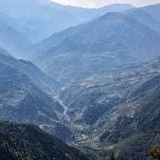
Uitzichtpunt
4.2 km
The confluence of two rivers
1.5 km
Uitzichtpunt
10.8 km
Uitzichtpunt
2.7 km
Uitzichtpunt
5.7 km
Uitzichtpunt
10.5 km
Uitzichtpunt
10.4 km
Uitzichtpunt
10.5 km
Uitzichtpunt
1.3 km
Uitzichtpunt
5.8 km
Beautiful views
2 km
Uitzichtpunt
8.5 km
Uitzichtpunt
8.5 km
Uitzichtpunt
8.5 km
Uitzichtpunt
8 km
Uitzichtpunt
8 km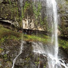
Jocho waterfall
5.7 km
Uitzichtpunt
10.5 km
Uitzichtpunt
5.9 kmBeoordelingen
Heeft u deze plek bezocht? Tik op de sterren om een beoordeling te geven en uw ervaring of foto's te delen met de community! Probeer het nu! U kunt het op elk moment annuleren.
Ontdek verborgen schatten op elk avontuur!
Van karakteristieke kleine cafeetjes tot geheime uitzichtpunten – ontvlucht de drukte en vind plekken die echt bij jou passen. Onze app maakt het makkelijk: spraakzoekopdrachten, slimme filters, geoptimaliseerde routes en authentieke tips van reizigers wereldwijd. Download nu en beleef het avontuur op je smartphone!

Een nieuwe benadering van toeristische ontdekking❞
— Le Figaro
Alle plekken die de moeite waard zijn om te ontdekken❞
— France Info
Een uitstapje op maat in slechts een paar klikken❞
— 20 Minutes